SO what is a Single Beam Survey? Today, information is a key factor for human beings to plan, understand, and take appropriate action to maintain a habitable and pleasant environment on Earth. Interesting enough, 80 percent of the earth’s oceans remain unexplored, despite their total coverage of 70 percent. The use of sonar technologies in exploration and research of the area in the ocean is among the important techniques that have developed
Bathymetry vs Hydrographic survey
Bathymetry is often described as the scientific study of water bodies such as oceans, rivers, lakes, and streams. The terms bathymetry and hydrography are often used interchangeably. However, many people don’t realise the differences between bathymetry and hydrography.
Bathymetry Survey is the study of the physical characteristics of a water body. There is so much more to Hydrography Survey than just the shape and features of shorelines, tides, currents, and waves. It also includes the chemical and physical properties of the water. The main methods used are single-beam bathymetry and multi-beam sonar. Among the purposes for which the collected data is used are:-
- Development of hydrographic models for floodplain analysis
- Helping marina owners for planning dredging and dock maintenance activities
- Assisting riparian landowners with bulkhead and dock permit applications
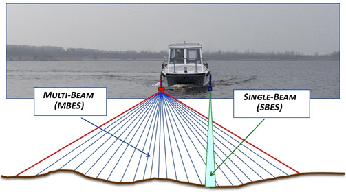
Single Beam Survey
To measure the depth of water directly beneath a surface, a single beam survey uses a single beam focus. These are usually used on small bodies of water. This is done using a single beam echo sounder.
These echo-sounders, which are also known as depth sounders, measure the travel time of a short sonar pulse to determine the depth of the water body. Echoes are generated by a transducer that emits a pulse below the surface of the water, and the pulse is received by the transducer. The sounder listens for the return echo at the bottom by using a single beam echo sounder.
But there are several errors encountered during this process. Some of them are below
- Pythagoras Error: – This is found when two transducers are used, one for transmission and the other for reception.
- Aeration Error:- If the sound is reflected from air bubbles, it will be shown as dots which is also known as aeration.
- Zero-Line Adjustment Error: – When the Zero is not adjusted accurately, it can lead to errors in reading.
- Cross Noise Error:- Aeration and Part of Transmitted pulse lead to the creation of cross nice.
- Multiple Echoes:-The Echo might get reflected multiple times from the bottom of the sea bed and provide multiple depth marks on paper.
- Stylus Speed Error:- Due to Fluctuation in voltage supplied, the stylus motor can cause an error in readings
- Velocity Of Propagation In Water:- the velocity of water changes with temperature, pressure, and salinity leading to significant errors
Echo Sounder Vs Sonar
Apart From the Echo sounder, sonar is also used in the study. The difference between echo sounder and sonar, while an echo sounder lets you view the seabed currently under the vessel using a fixed mount transducer. Sonar provides a Better view of the waters forward, starboard, port, or aft of the vessel using a hoist-operated transducer element that scans 360 degrees. The tilt of the transducer element can also be adjusted.
Types of Researches
Now bathymetric surveys help in various researches like:-
- water-quality studies
- scour and stabilization
- flood inundation
- contour of streams and reservoirs
- leakage
- storage and fill in reservoirs and ponds
- dam removal
- biological and spill
And Apart from Echo Sounder, we also use sonars which are mainly of two categories Single Beam and Multi-beam. The single Beams sonar has a typical beam-width of 10-30 degrees. While the multi-beam Systems provide a series of slant range and elevation angle estimates along a fixed azimuth and are more preferred as it provides a measure of an entire area rather than a single line of the seafloor.
Conclusion
Overall The single beam surveys are quite cost-effective and can be used to study and explore the oceans in a better way and can serve greatly in practices of flood and other natural disasters study. So if you have a water body and want to know what lies beneath the surface get in touch today to discuss you project/ requirements.
Recent Comments