Side Scan Sonar Surveys
Total Hydrographic are your certified Hydrographic Surveyors and Marine Mapping/GIS professionals.
Our Services
Bathymetric Surveys
Side Scan Sonar Surveys
Hydrographic Data Analysis
Terrestrial Surveying
Hydrographic Consultancy
Bathymetry is the study and mapping of the sea floor. Bathymetric surveys allow for us to measure the depth of a body of water as well as map its underwater features. Bathymetic data is used in a range of applications, some include:
- Hazard Detection
- Safety of Navigation and Nautical Charting
- Determiniation of Maritime Boundaries
- Environmental Management, including developing baseline data
- Research for Coastal and Marine Processes
- Installation of Maritime infrastructure
At Total Hydrographic we gather bathymetric data in a variety of different methods and equipment. Our Multibeam Echosounder (MBES) is a full bathymetric seafloor coverage system. The MBES system emits 512 beams in a fan shape beneath the boat allowing the system to capture up to 200,000 soundings per second and ensure maximum coverage of the seafloor.
Our Single Beam Echosounder (SBES) on the other hand, captures data using a single beam directly below where the system is mounted. Single Beam surveys are at a pre-defined line spacing; for example 2m, 5m, 20m. The size of these intervals determines the final resolution of the survey.
Multibeam survey and Single Beam surveys are each best suited to their own individual set of circumstances, locations and client needs. Total Hydrographic can help by recommending a particular solution specific to your own requirements and priorities as both MBES and SBES have their individual strengths and capabilities.
Hazard Detection and Debris Clearance
Hazard Detection and Debris Clearance is a necessary support service for any organisation that manages a body of water. It is crucial to identify new or existing obstructions from natural or anthropogenic events, and to determine safe recreational use for the public.
Our hydrographic survey team can offer bathymetric and side scan surveys that utilise in house R2Sonic Multibeam Echo Sounders (MBES) and/ towed or hull mounted Side Scan Sonars (SSS) to locate and identify hazards & debris. We can operate these systems concurrently or separately, to scan large swaths of river, sea, lake or dam beds in an efficient manner and provide detailed data on the hazards present in a format that best suits you.
Total Hydrographic maintains this equipment and capability in house and as a result, mitigates the risk of project delays. From the results of your survey, all hazards and debris will be located and identified, allowing you to be confident in what lies below the waterline.
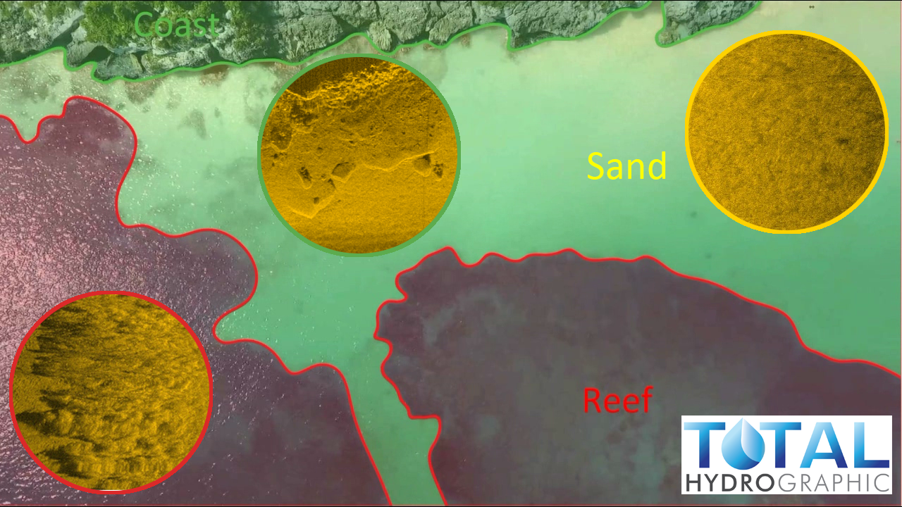
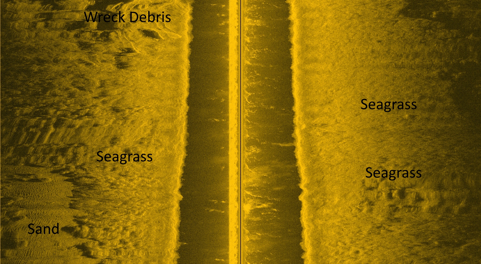
Marine Habitat Mapping & Seafloor Classification
The ocean is an unbelievably large expanse, of which most of the bottom can’t be seen by the naked eye from the surface. Determining the type of seabed on a small scale is easy enough with divers or mechanical sampling. However attempting to classify the seabed on a large scale is not efficient via these means. Side Scan Sonar (SSS) makes this a much more efficient process.
Our survey team can rapidly deploy our in house SSS system or hire the most efficient system for the project. Side scan can offer high resolution and spatially detailed imagery across its swath, making it an efficient and cost effective tool for providing georeferenced maps of seabed zones. Using this map, less seabed samples are required and can be targeted based on the map zones.
Our finished product is able to provide a properly presented map with accurate georeferencing that will be able to reveal the diversity, distribution and classification of your area of interest. Not only does this save you money but it also minimises the requirement for high risk diving activities.

3D Channel Design
The objectives of the survey was to provide full bathymetric survey and provide a volume assessment for the renourishment site to meet the 3D design model. The data that we provided allowed the client to make an informed decision, based on quantitative and visual data presentation, as to the best mode of practice for dredging and renourishment operations.

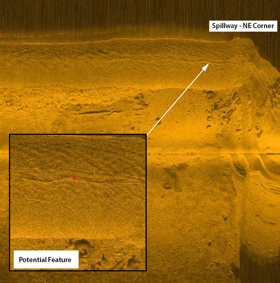
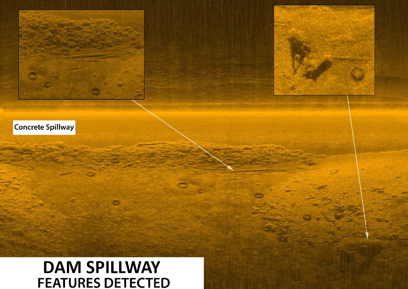
Reservoir Study
In a drought prone country like Australia, where millions of people rely on the country’s many reservoirs for a safe and dependable water supply – efficient, forward thinking and strategically planned reservoir management is crucial. The risk involved in reservoir management can be mitigated with quick access to relevant and accurate data.

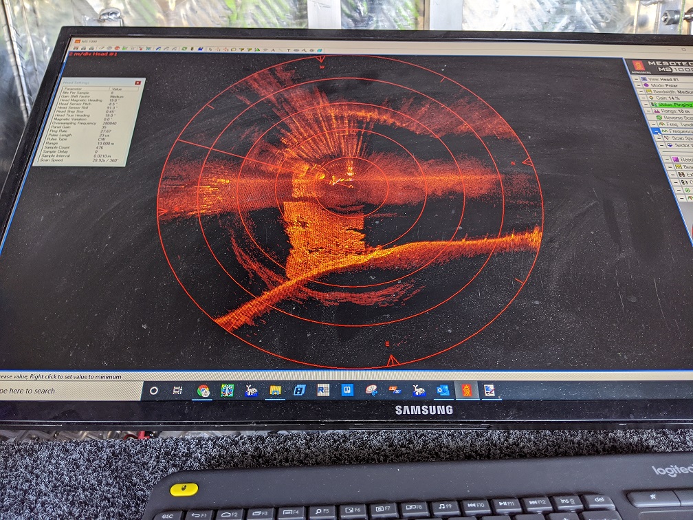
Underwater Inspection Survey
Total Hydrographic specialises in underwater survey and scanning and can utilise a variety of survey sensors to capture relevant data for clients. The Kongsberg MS1000 Mechanical Scanning Sonar used by Total Hydrographic is an example of a system that is ideal for inspecting underwater structures.
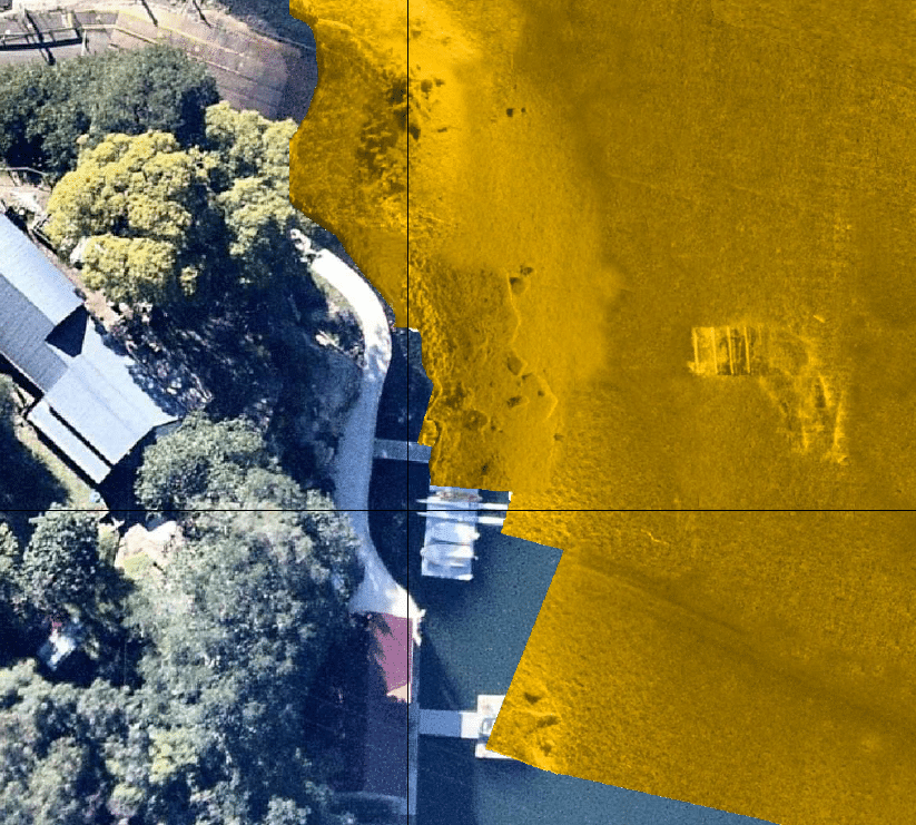
Underwater Asset Inspections
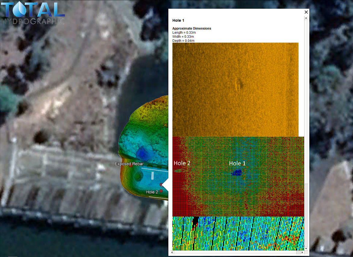
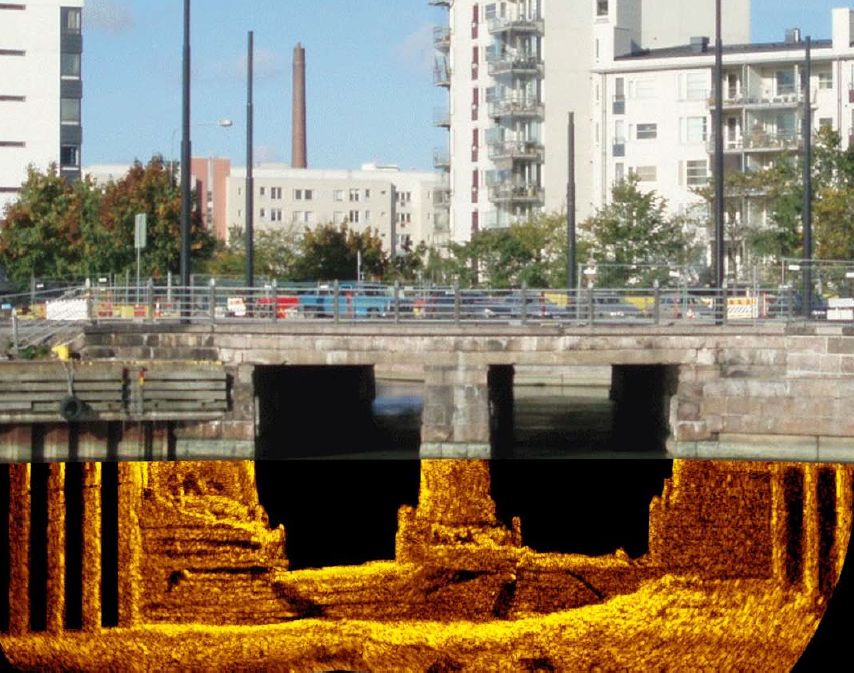
Management of assets in the marine environment has many technical issues, the most challenging is not being able to get a visual below the waterline. Monitoring material movements and the foundations of your asset can be crucial in ensuring their integrity. With flowing water, scouring can be a big problem and can take place quickly in extreme marine environments.
Our experience working with a range of side scan sonar systems enables us to use the right tool for providing below water line imagery on your assets. We have utilised these tools as part of bridge inspection and dam wall surveys, with the sonar providing high resolution imagery on deformation, potential scouring, cracks, spalling and other defects.
The custom built bow frame on our survey vessel Total 2 has been deployed to allow us to operate safely in close proximity to marine assets, while gaining imagery that can be used to make diving inspections safer and more efficient.
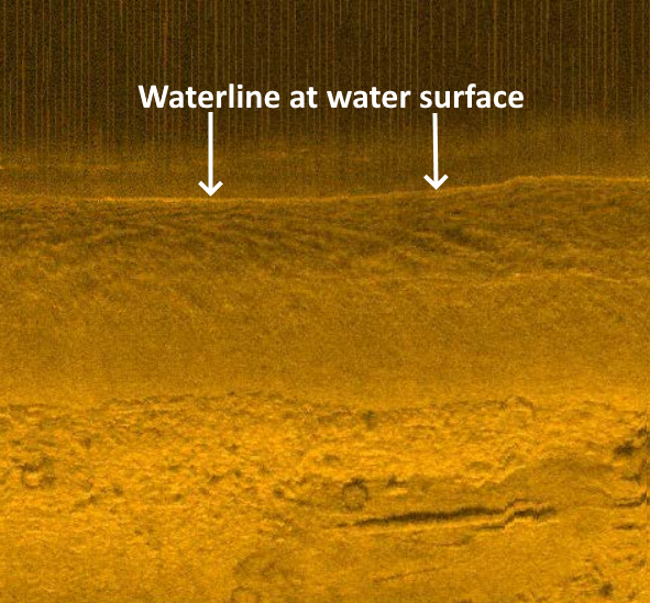
Coastline and Waterline Capture
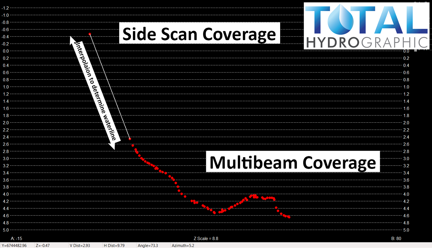
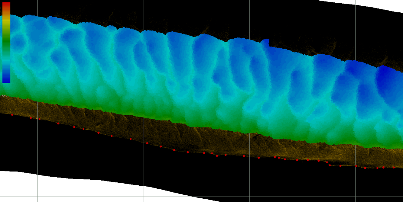
One of the most difficult areas to survey, for either topography or bathymetry, is where the water meets the land – the waterline. If you are having a survey conducted for capacity analysis then this waterline area is crucial as the surface is usually the largest expanse of a water body and can contribute to a significant volume of water.
Total Hydrographic has a very effective solution to capturing this location of waterline by using Side Scan Sonar (SSS). Our in house system is optimised for shallow water and can be rapidly deployed on almost any vessel. Data capture is also very efficient in providing you crucial data for your survey. The system is particularly effective in tree covered creeks and rivers where pedestrian access is not an option for capturing the waterline terrestrially.
By implementing a SSS survey into your package, Total Hydrographic can greatly increase the accuracy of your overall capacity study. In any situation where the collection of the waterline information is important, SSS can provide a safe, efficient and accurate solution to your needs.

Harbour Dredging
A corner stone of Total Hydrographic’s operations is to provide underwater survey solutions that can help Port and Harbour Authorities determine an appropriate dredging solution for their waterways. Dredging solutions often takes place because of sedimentation gradually encroaching in navigable waterways, and or when Port and Harbour authorities look to expanding their operations.
")
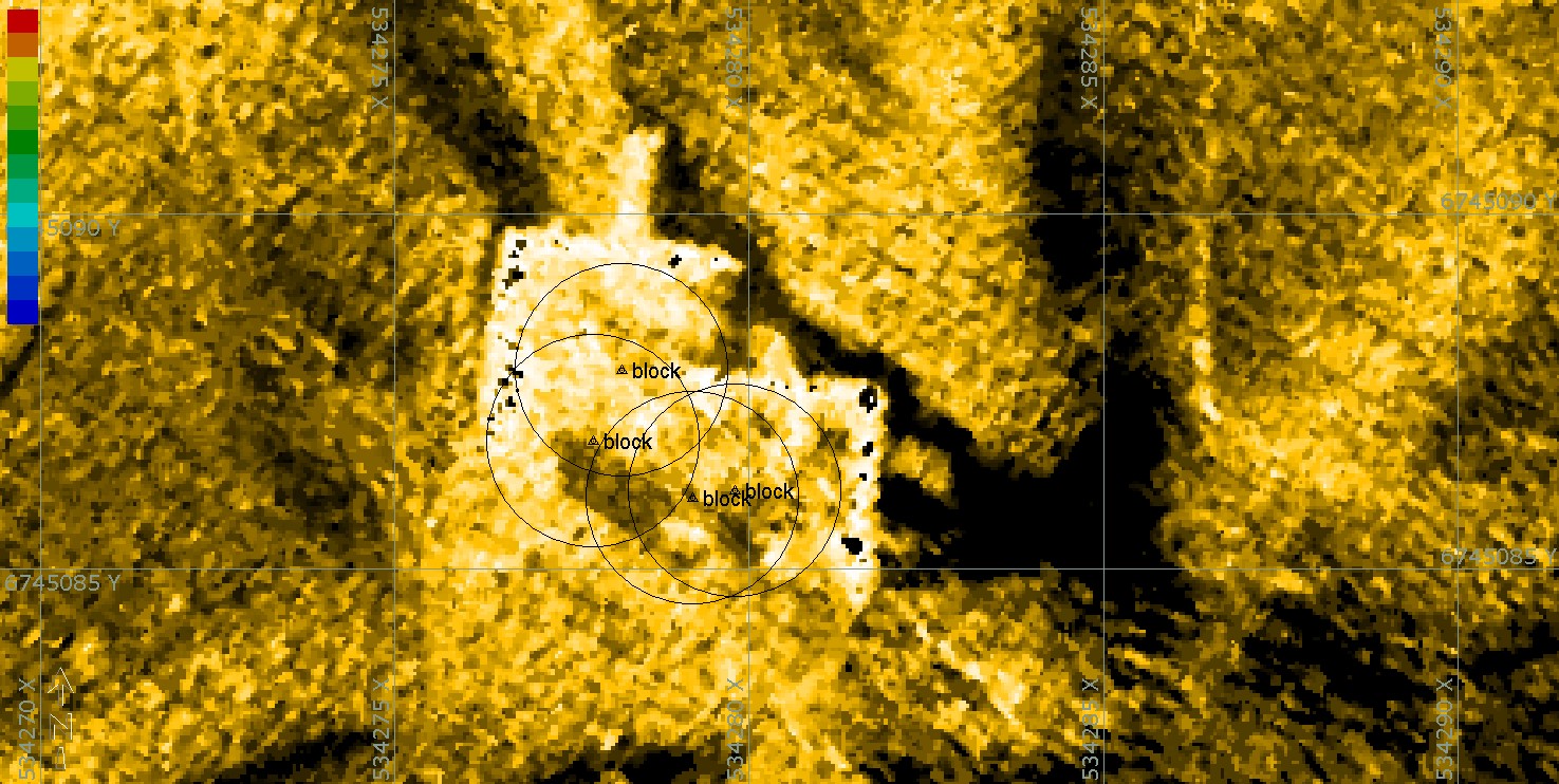
A Rockwall
The results from a rock wall scanning project were processed and thoroughly analysed. The scan was undertaken to validate that the rock wall had been accurately constructed as per its design. Cross Section Profiles were extracted from this data and can be seen in the images.

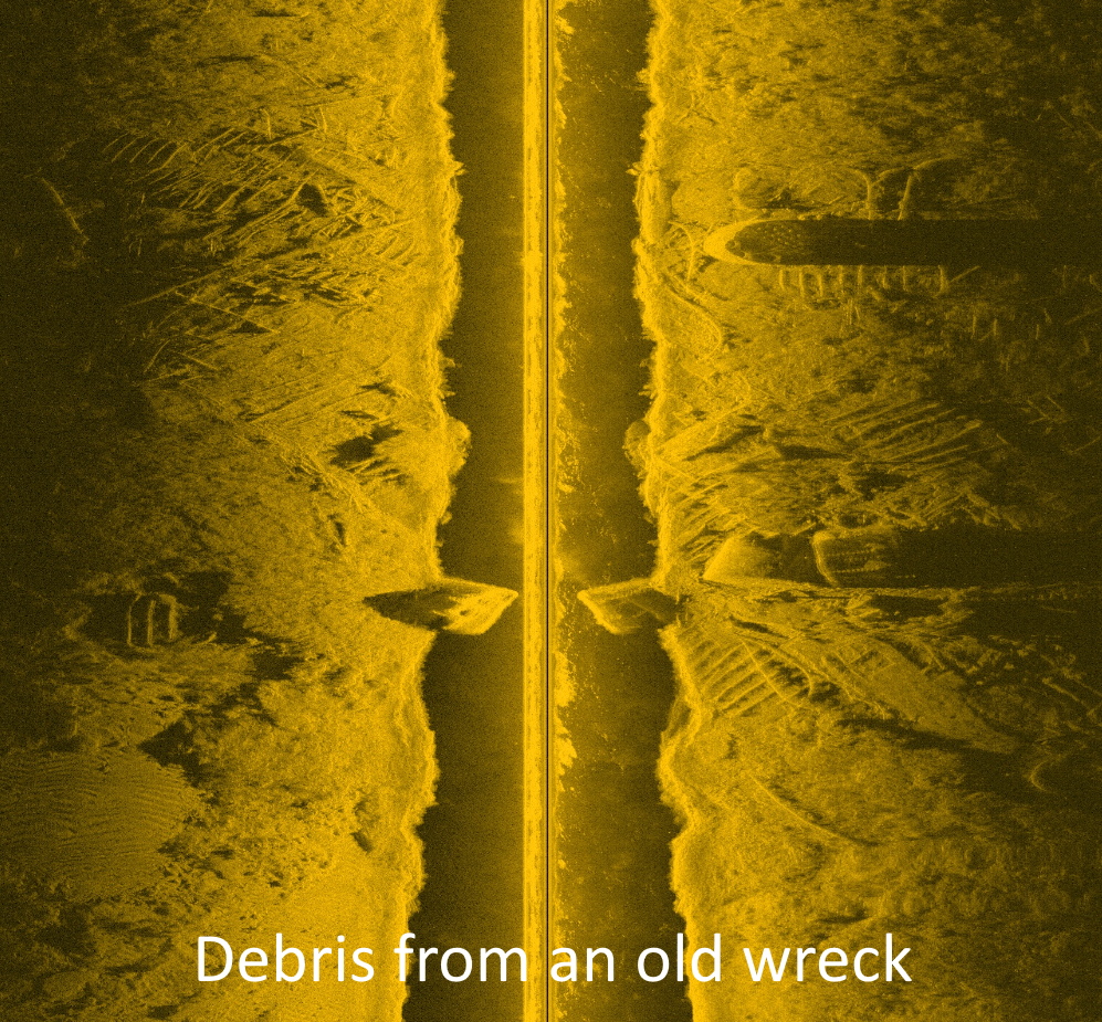
Submerged Trees
This image is an extract from a hazard clearance survey of a lake. The client needed to know that there was a minimum clearance depth of water available at particular water levels. There were many hazards on the lake bed, however the survey revealed that they were all deeper than the client’s required minimum depth.
Hydrography is the science of measuring and describing physical features within water bodies. Hydrography is used for navigation, habitat mapping and hazard identification.
Address
14/75 Endeavour Way, Sunshine West VIC 3020
79 Cook Road, Bli Bli, 4560, QLD