How We Do Terrestrial Surveying?
Total Hydrographic are your certified Hydrographic Surveyors and Marine Mapping/GIS professionals.
Our Services
Bathymetric Surveys
Side Scan Sonar Surveys
Hydrographic Data Analysis
Terrestrial Surveying
Hydrographic Consultancy
Bathymetry is the study and mapping of the sea floor. Bathymetric surveys allow for us to measure the depth of a body of water as well as map its underwater features. Bathymetic data is used in a range of applications, some include:
- Hazard Detection
- Safety of Navigation and Nautical Charting
- Determiniation of Maritime Boundaries
- Environmental Management, including developing baseline data
- Research for Coastal and Marine Processes
- Installation of Maritime infrastructure
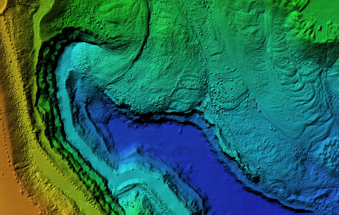
At Total Hydrographic we gather bathymetric data in a variety of different methods and equipment. Our Multibeam Echosounder (MBES) is a full bathymetric seafloor coverage system. The MBES system emits 512 beams in a fan shape beneath the boat allowing the system to capture up to 200,000 soundings per second and ensure maximum coverage of the seafloor.
Our Single Beam Echosounder (SBES) on the other hand, captures data using a single beam directly below where the system is mounted. Single Beam surveys are at a pre-defined line spacing; for example 2m, 5m, 20m. The size of these intervals determines the final resolution of the survey.
Multibeam survey and Single Beam surveys are each best suited to their own individual set of circumstances, locations and client needs. Total Hydrographic can help by recommending a particular solution specific to your own requirements and priorities as both MBES and SBES have their individual strengths and capabilities.
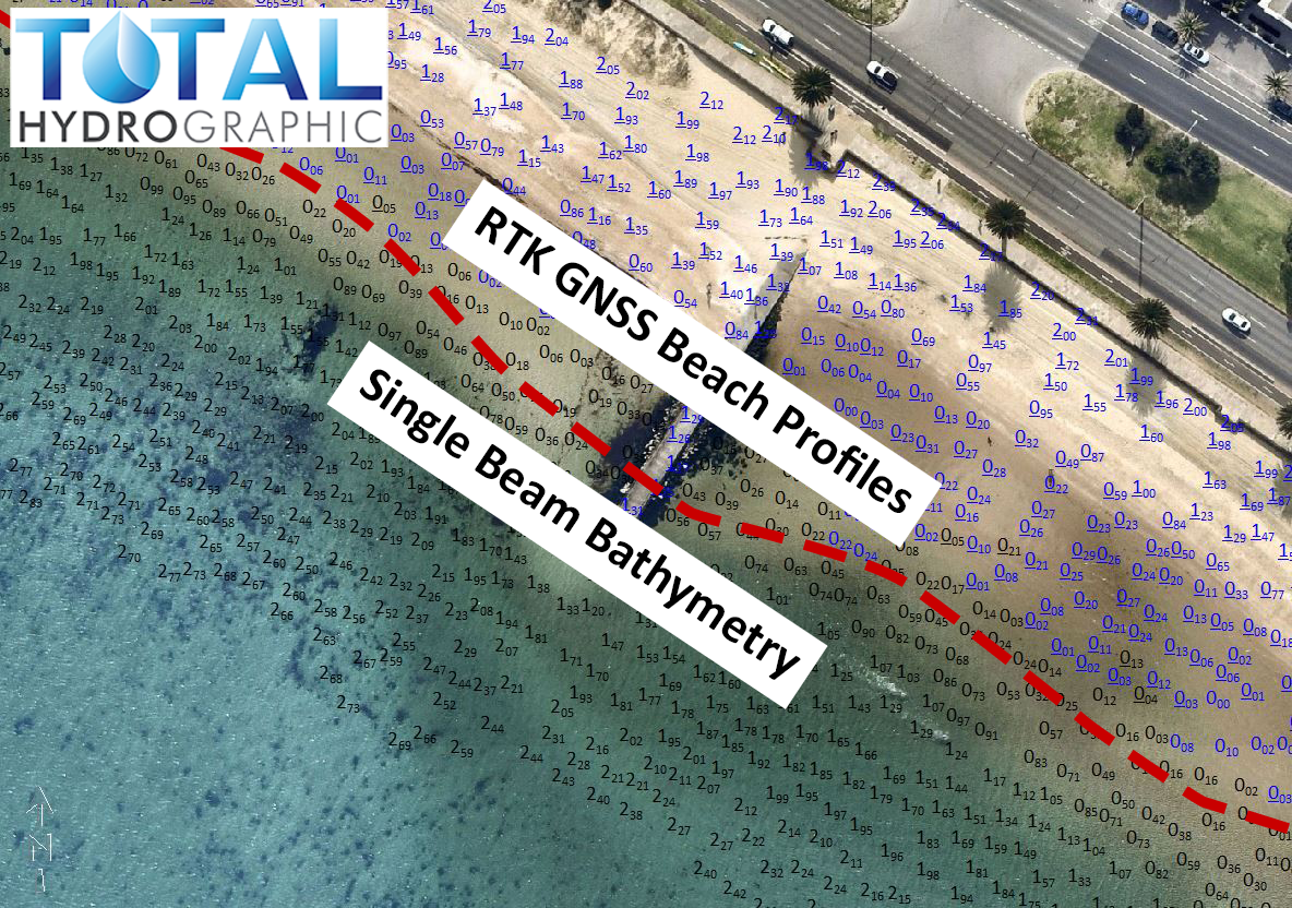
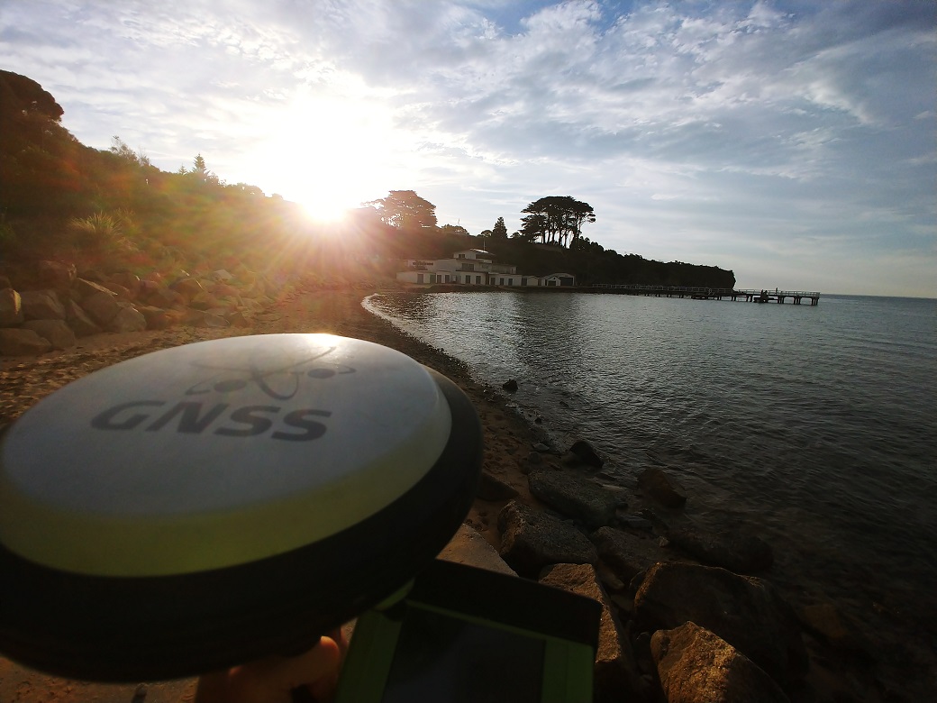
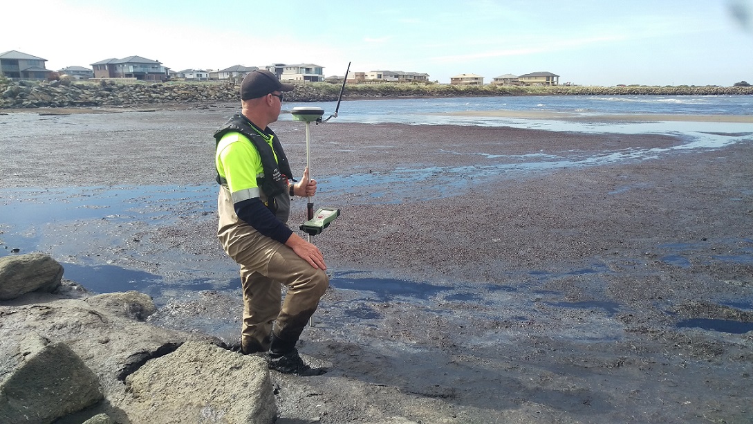
RTK GNSS Profiles
RTK GNSS profiles are a well established method of capturing data in areas above water and in extreme shallows where bathymetric systems may not operate efficiently. Profiles can extend above water down to approximately 0.5m water depth to ensure there are no gaps in coverage between bathymetry and topography, ensuring a complete and seamless model of the survey site.
RTK GNSS Profiles are an essential tool for coastal renourishment and beach foreshore surveys where variability of water level and weather conditions can limit data coverage for other methods such as drone photogrammetry. Perfect for cross sectional profiles and for areas that simply cannot be accessed any other way.
Total Hydrographic’s RTK GNSS sensors can be utilised with minimal lead time and as a solo operation. This often presents itself as the ideal cost effective solution for small to medium projects that require topography to accommodate a hydrographic survey.
Mobile Laser Scanning
For clients, such as Dam and Reservoir managers or clients with maritime infrastructure, that are looking for 3D digital representation of their site above and below the waterline. Our Mobile Laser Scanning services, unlike traditional on-foot topographic surveys, can capture thousands of points per second whilst being integrated to our motion sensor unit to accommodate for vessel movement and other environmental conditions.
Mobile Laser systems such as the Carlson Merlin can be a viable topographic solution for capturing large sections of coastline or river bank, where it is not efficient, practical or safe for a surveyor to traverse on-foot. Total Hydrographic has experience in utilising MLS in projects such as reservoir survey scanning, harbour breakwall monitoring and wharf structural integrity inspection.
Save time whilst mitigating safety hazards by utilizing an on-vessel MLS system without compromising the accuracy of the data

3D Channel Design
The objectives of the survey was to provide full bathymetric survey and provide a volume assessment for the renourishment site to meet the 3D design model. The data that we provided allowed the client to make an informed decision, based on quantitative and visual data presentation, as to the best mode of practice for dredging and renourishment operations.

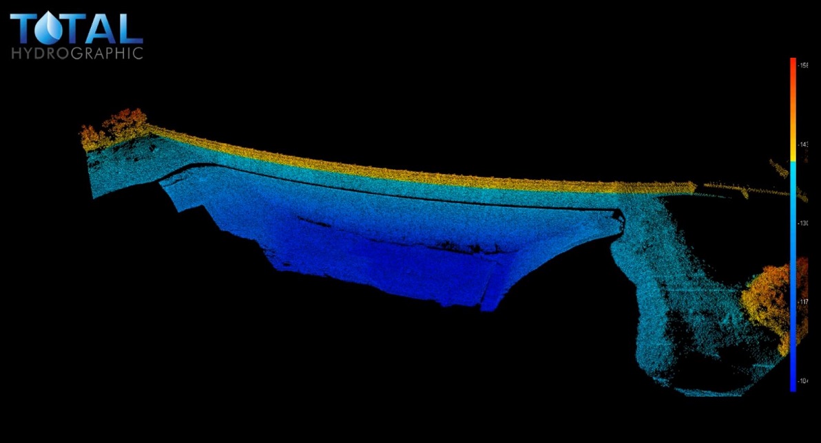
Reservoir Study
In a drought prone country like Australia, where millions of people rely on the country’s many reservoirs for a safe and dependable water supply – efficient, forward thinking and strategically planned reservoir management is crucial. The risk involved in reservoir management can be mitigated with quick access to relevant and accurate data.

Underwater Inspection Survey
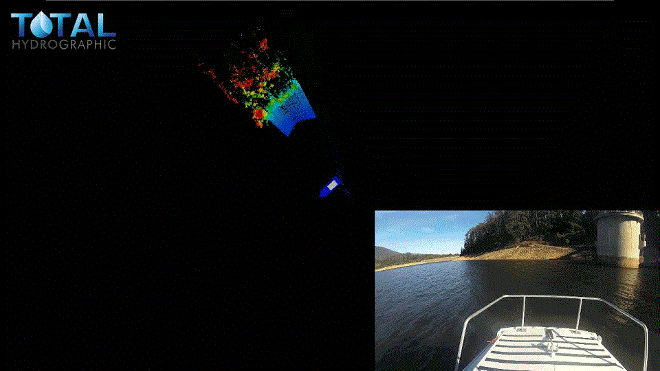
Total Hydrographic specialises in underwater survey and scanning and can utilise a variety of survey sensors to capture relevant data for clients. The Kongsberg MS1000 Mechanical Scanning Sonar used by Total Hydrographic is an example of a system that is ideal for inspecting underwater structures.
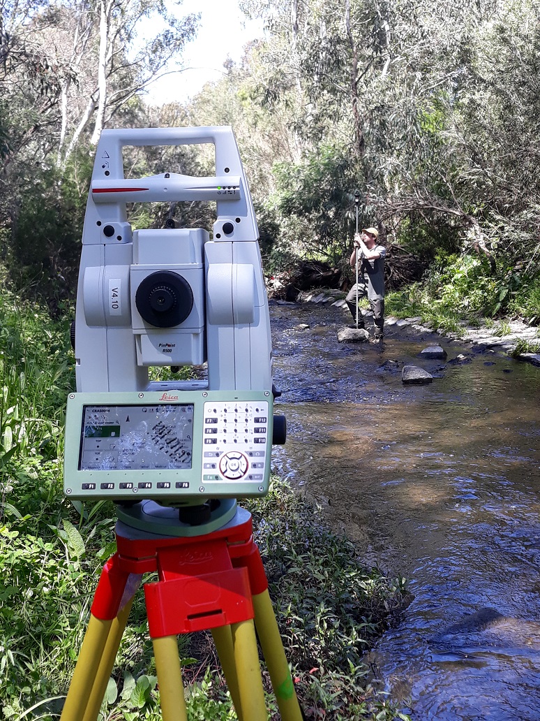
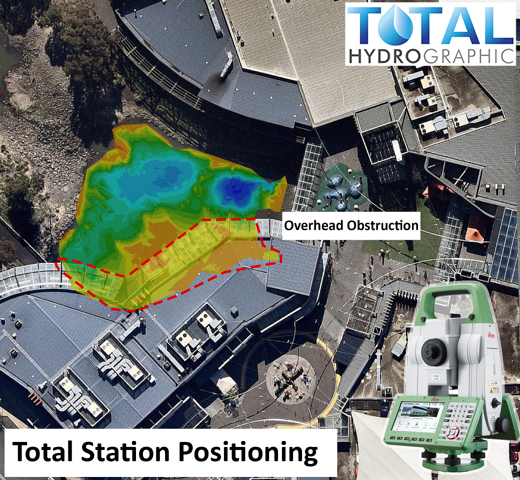
Total Station/Levelling Run
When the RTK GNSS observations cannot achieve the objective, traditional land survey tools such as Total Station can be implemented. Total Stations provide the greatest precision possible with observations to the millimeter.
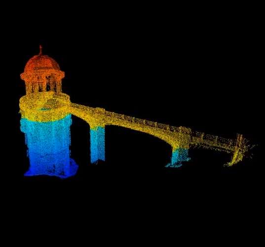
Examples of Total Hydrographics total station use include surveying the lowest points of bridges and overhead obstructions relative to Highest Astronomical Tide (HAT) for safe nautical passage.
Total Stations are also invaluable positional tool during autonomous survey vessel operations where overhead obstructions restrict GNSS coverage. Total Hydrographic has experience in integrating total station positional strings into hydrographic software in real time for remote reservoir surveys and water bodies with no clear sky coverage.
Aerial Photogrammetry Survey
Photogrammetry captured by drone can cover large areas of foreshore and coastal features efficiently, safely and accurately when used with appropriate ground control. Often captured at low tide, entire sections of beach can be captured and merged seamlessly with bathymetry.
Total Hydrographic can utilise its own DJI Phantom 4 drone or engage an external provider to implement the optimum drone solution for your project. The capture of topographic data with drones can significantly reduce the time and manpower of traditional land based methods.
They are especially useful for mitigating environmental impacts in environmentally sensitive areas such as foreshore dune systems. They also provide a survey solution to unreachable areas, where harsh terrain or steep slopes might prevail, making it possible to gather accurate survey data along rocky shore environments.
Data capture from drones is comprehensive in a single flight, data collected on the ground or infrastructure can be used to give you accurate measurements of distance and elevation. The imagery on infrastructure is a great tool for initial inspection of asset health, that can be tied in with below the water line side scan imagery or 3D point cloud data, providing a holistic view of the site.


Harbour Dredging
A corner stone of Total Hydrographic’s operations is to provide underwater survey solutions that can help Port and Harbour Authorities determine an appropriate dredging solution for their waterways. Dredging solutions often takes place because of sedimentation gradually encroaching in navigable waterways, and or when Port and Harbour authorities look to expanding their operations.
")
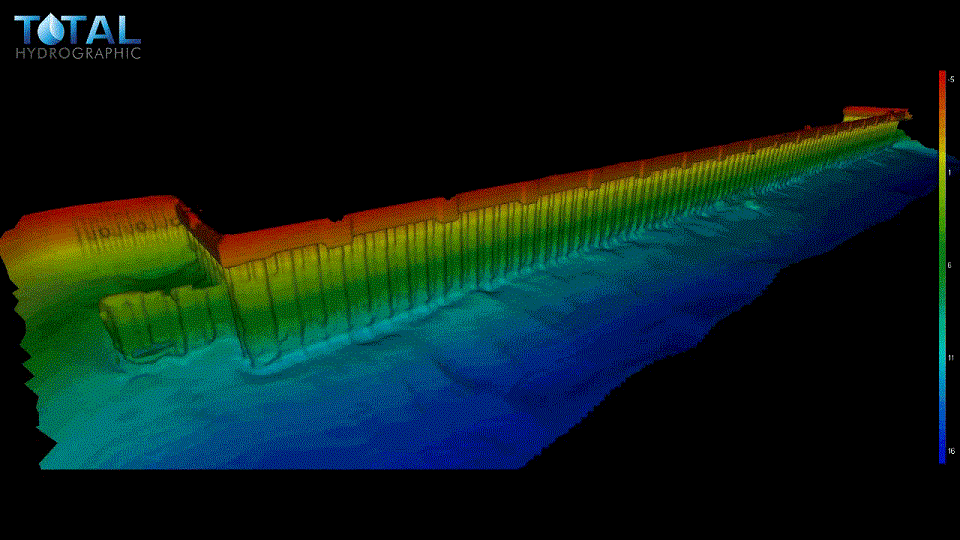
A Rockwall
The results from a rock wall scanning project were processed and thoroughly analysed. The scan was undertaken to validate that the rock wall had been accurately constructed as per its design. Cross Section Profiles were extracted from this data and can be seen in the images.

Submerged Trees
This image is an extract from a hazard clearance survey of a lake. The client needed to know that there was a minimum clearance depth of water available at particular water levels. There were many hazards on the lake bed, however the survey revealed that they were all deeper than the client’s required minimum depth.
Hydrography is the science of measuring and describing physical features within water bodies. Hydrography is used for navigation, habitat mapping and hazard identification.
Address
14/75 Endeavour Way, Sunshine West VIC 3020
79 Cook Road, Bli Bli, 4560, QLD