A map of marine ecosystems across time may be used to understand their evolution better. Marine ecosystems are investigated, representative species are chosen, and the ecosystems are plotted via Marine Habitat Mapping of the world’s oceans.
One million species are predicted to live in the ocean’s various ecosystems, although just 5% of the ocean’s surface has been explored. The seafloor is intricate and dynamic in both space and time. This system is home to a diverse spectrum of biological species and communities, geomorphological traits, and complicated marine ecosystems.
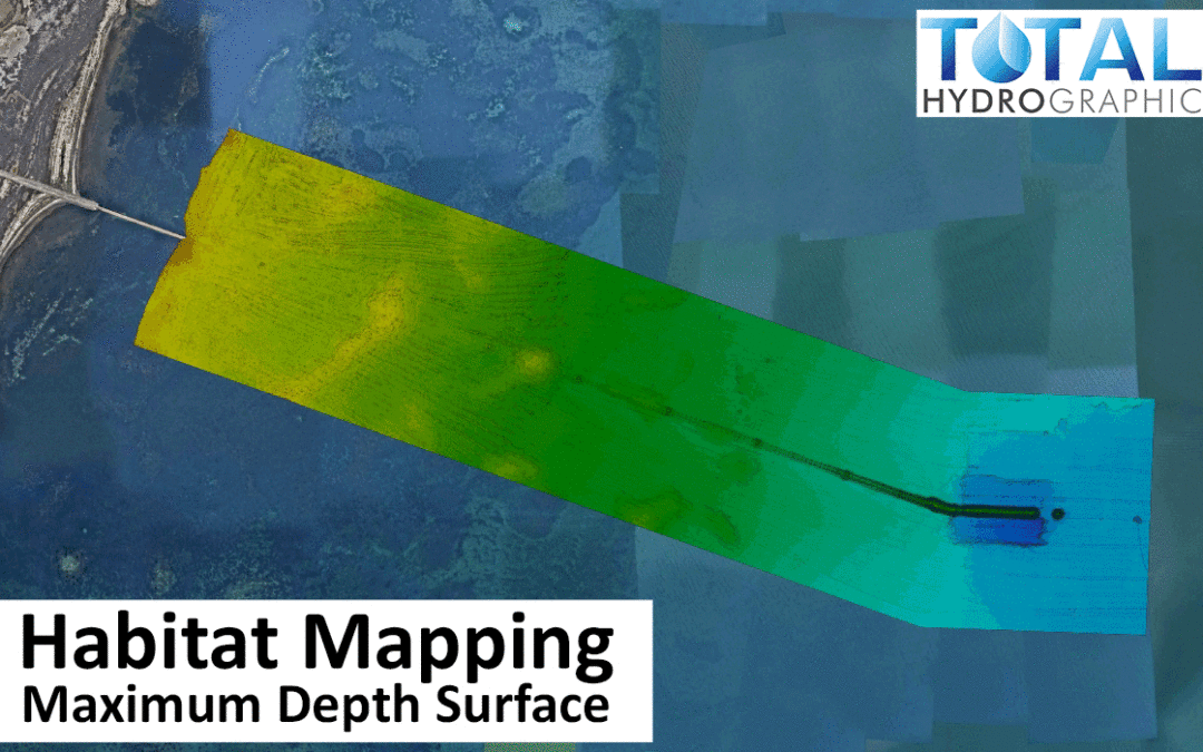
What does the term ‘Marine Habitat Mapping’ mean?
Marine Habitat Mapping (MHM), a valuable collection of field methods that enables the performance of integrated ecosystem assessments, provides direct support for EBM. This article aims to investigate MHM strategies through the lens of biodiversity models and ecologically oriented management.
Top 7 Ways Marine Habitats are Mapped
A map is a handy tool for managing marine resources.
Fisheries scientists may use habitat maps to determine if their species have adequate growth substrate. Additionally, it may aid resource managers in the planning and siting projects, including dredging, cable and pipeline routes, aquaculture sites, and no-wake zone designation. However, how do habitat maps function? The following are some of the most often used techniques for mapping habitats.
Entails identify ecosystems via the use of GIS.
Using GIS, deep-sea ecosystem mapping is critical for understanding the ocean’s richness and size. Marine resources and ecosystems are essential for regional planning. In this case, mapping is vital. They can help managers plan for management and conservation in a specific region. The data is geo-referenced and often derived from other groups’ work. Some of the methods used to manage marine environments include mapping, mapping and mapping. While not exhaustive, it gives an idea of the data collected. This group is charged with assessing habitats and compiling data.
Collecting data on each marine habitat is required to map them.
Mapping marine habitats entail gathering data on each particular marine environment. The species examined are classified as vulnerable or endangered by the federal government. In the United States, the map-making process is mainly focused on terrestrial species, although it also includes fish and marine invertebrates. The model’s data is derived from simple observations and public sources. Users may use this data to determine how effectively certain habitat types support the development of specific species.
Aids in the public’s comprehension of the marine environment.
A map, for example, may assist in explaining the distinction between benthic and epibenthic creatures. In certain instances, it may deliver more valuable information to the public. In some cases, this knowledge may assist the public in improving stewardship and promoting community-level action to maintain a specific habitat. It may help the people in comprehending what is occurring in their waters.
It helps managers assess ecosystem size and value to the sea.
Marine habitat maps are an invaluable resource for regional planning and conservation. It assists managers in determining the size of various ecosystems and their relative significance to the sea. It is a critical tool for managers since it enables them to plan for future fisheries management. Although the data acquired is difficult to obtain and use, it is essential for regional planning in coastal ecosystems. Marine Mapping is one of the most cutting-edge techniques.
Scientific research relies on detailed habitat maps.
Creating a detailed habitat map enables scientists to understand better and protect the marine environment. Additionally, it educates the people about its natural resources and the critical nature of ocean protection. The public needs to understand the value of marine ecosystems and safeguard them. The scientific community needs information on their efforts to protect the environment. They can aid marine ecology if they can identify habitats.
Critical for ocean conservation.
The oceanic topography is the most accurate indicator of an area’s environment. Physiographic maps depict the ocean’s ecosystems and species. It is critical to map these places if they are to be protected. These maps may assist in gaining a better awareness of and protection for the maritime environment. Additionally, it benefits the environment. Its mapping enables academics to better comprehend the many ecosystems in the water.
Bottom-line
The most often used seven approaches for Marine Habitat Mapping are based on species distribution and environmental characteristics. These surveys, conducted at particular sites on the bottom, might take years. When the data is analysed, a map of the marine environment may be constructed. And it is conceivable to completely cover the ocean floor with a piece of acoustic or optical equipment.
Recent Comments